


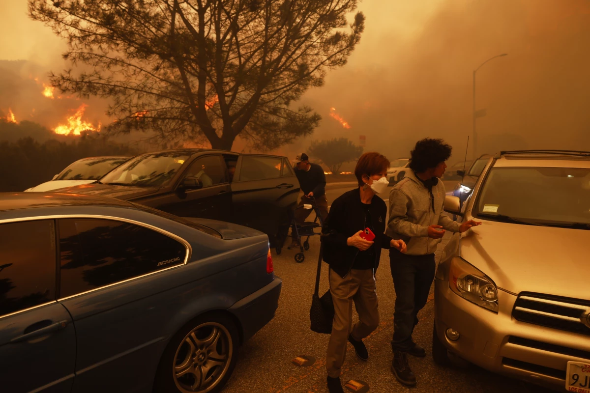
When the Palisades Fire exploded, people rushed to their cars to evacuate, but found the roads clogged with traffic. As the flames approached, police officers told drivers to flee on foot. The abandoned cars were later cleared with a bulldozer.
The scene echoed evacuations from other recent wildfires, ones with far deadlier results. In both California’s Camp Fire in 2018 and in Lahaina, Maui in 2023, residents died in their cars or fleeing on foot when the streets were blocked with standstill traffic and they were overtaken by the blaze.
With wildfires spreading faster as the climate gets hotter, evacuation is becoming even more critical. In high winds, like those Los Angeles saw this week, firefighters have little chance of slowing or stopping the blaze. Getting people out is the only option.
Still, many communities are lagging on evacuation planning, studies have found. And many face similar chokepoints, with narrow, winding roads making it difficult for residents to get safely out of neighborhoods.
“There are hundreds, if not thousands of communities like this, even just in the U.S. West, let alone worldwide,” says Tom Cova, a professor of geography at the University of Utah who studies evacuation. “We need to do everything we can to make this go smoothly. The worse the egress and the greater the fire risk, the more there’s a need for this.”
In some communities, local residents have helped lead wildfires preparation efforts, creating all-volunteer fire councils that help identify evacuation routes and assist homeowners in making their houses more resistant to wildfire.
“Our fire-prone areas are also beautiful areas, but we’ve realized that with that opportunity to live in a place like that comes a responsibility,” says Ryan Ulyate, resident of Topanga Canyon and co-president of the Topanga Canyon Fire Safe Council. “And that means you’ve got to do more.”
Communities unprepared for large-scale evacuations
With the powerful Santa Ana winds topping 60 miles per hour, the fires in Los Angeles grew explosively within hours of starting. In those conditions, firefighters had little hope of containing the spread.
“California has some of the largest numbers and best trained firefighters probably in the world,” says Michele Steinberg, wildfire division director at the National Fire Protection Association. “Even with that, there simply are not enough people and resources to attack all these fires simultaneously and to deal with the fact that the wind is pushing them that fast. That is the reality.”
When people in the Pacific Palisades got an alert to evacuate, they found many roads with standstill traffic. Tucked away in the hills, the neighborhood has few main roads going in and out. As the wildfire advanced, police told drivers to get out and continue on foot. Sitting in traffic is perilous during an extreme fire. In both the Camp Fire and Lahaina Fire, people died in their cars or on the street as they fled.

Evacuation planning is largely done by local governments, but the level of preparation varies greatly. In a review of 11 wildfires in California, one study found that some local governments were not prepared, and “nearly all agencies do not have the public resources to adequately and swiftly evacuate all populations in danger.” Other studies have found many communities around the country lack adequate routes for evacuation.
What communities can do
Technology is coming to the aid of some communities. For those that can afford commissioning studies, computer simulations can show how long it will take to evacuate neighborhoods and where the critical bottlenecks are. Some systems are being used by fire departments during wildfires to make evacuations more efficient. If there’s time, evacuating people by zones sequentially can help traffic flow, since it prevents too many cars leaving at the same time.
Communications are critical during wildfires, especially to alert people when it’s time to leave. Many communities use Wireless Emergency Alerts, which sends text messages to everyone within specific geographic locations. But cell service often goes down during wildfires, so having alternate ways of getting the message out is key. Some communities have installed sirens that can play messages, giving detailed directions about what to do.
Still, in extreme fires, even the best evacuation plans may fall short. Many communities have grown substantially, allowing building over decades without adequate evacuation planning, especially given a dire need for housing in places like California.
“I think the stage is set over a long period of time, decades of development of certain types of homes that are in flammable regions with no egress,” Cova says. “And then you have first responders and emergency managers that are charged with dealing with it and it’s a losing proposition.”
One solution is building new evacuation routes, but that’s a challenging prospect in heavily developed areas. After their devastating fires, both Paradise and Lahaina saw an opportunity to improve roads and connect neighborhoods with limited egress. But building new roads or expanding existing ones often requires going through private property. A major road project in Paradise is costing hundreds of millions of dollars, far exceeding what the city can pay for on its own after being hit with a disaster.
Community groups stepping in
As Ryan Ulyate prepared to evacuate his Topanga Canyon home, he stayed surprisingly calm. The Palisades Fire was encroaching on the area, but he had spent years helping prepare his community for wildfires. He already had a checklist about what to take ahead of time and quickly packed his car.
“When the evacuation order was given, I got in the car and said goodbye to my house,” he says. “And I’m hoping that when I return there will be a house there.”
Ulyate helped create the Topanga Canyon Fire Safe Council in 2010, after he felt there weren’t enough discussions about the wildfire risk. Topanga Canyon has one road leading in and out, making it extremely vulnerable to fast-moving fires. The council helped lead a project with authorities to clear the flammable vegetation along the road, in order to make it safer during an evacuation.
His group also helps educate homeowners about how to make their houses more resistant to wildfire. Wildfires are largely spread through embers that are driven far from the fire itself, which can ignite trees, roof shingles or even dried leaves sitting in gutters. Clearing flammable brush and vegetation, especially in the area directly around the house, is a key, as well as using fire-resistant siding and roofs when home upgrades are done. Studies show some of these improvements have saved houses in previous fires.
“People are receptive, but we still have a long way to go,” he says. “It’s not something that everybody knows about. We’ve educated a certain amount of people, but in order for this to really be successful, entire communities need to do these kinds of things.”
Around the country, more local volunteers are creating fire councils and participating in the Firewise USA program, run by the National Fire Protection Association. It gives communities guidance and checklists on how to improve their fire safety. It often creates a pathway for citizens to work with local officials and help spur key discussions about evacuation.
A key thing, Steinberg says, is not to assume the preparation has already been done.
“The bigger the problem, the less the concern,” Steinberg says. “It’s a well-studied phenomenon apparently that the bigger and scarier the problem, the more likely people are to think that someone else is taking care of it. And I would say wildfire is the perfect example of that kind of thing.”
Transcript:
JUANA SUMMERS, HOST:
People fleeing the Palisades fire in Los Angeles found the roads jammed with traffic. As the flames approached, some abandoned their cars, and those empty vehicles had to be pushed out of the way by a bulldozer. The Pacific Palisades has few roads in and out. That’s a situation many other communities are in, and many of those communities are also lagging in evacuation planning. Lauren Sommer from NPR’s climate desk is here to talk about the lessons from these fires. Hey there.
LAUREN SOMMER, BYLINE: Hi, Juana.
SUMMERS: So Lauren, I mean, tens of thousands of folks have been told to evacuate in the past few days. Tell us what made this particularly challenging.
SOMMER: Yeah. The main thing has just been the speed of these fires. High winds made them spread incredibly fast, and, you know, that meant there was very little time to get people out. And for some people, there’s still this expectation that firefighters will be able to stop it or slow it down. I spoke to Michele Steinberg at the National Fire Protection Association about that.
MICHELE STEINBERG: California has some of the largest numbers and best-trained firefighters probably in the world. Even with that, there simply are not enough people and resources to attack all these fires simultaneously and to deal with the fact that the wind is pushing them that fast. That is the reality.
SOMMER: And then the other problem is that some of these neighborhoods have very few ways in or out, and so the roads quickly get clogged.
SUMMERS: And Lauren, as we mentioned, there are lots of other communities that face these types of bottlenecks in evacuating. Is that right?
SOMMER: Yeah. I mean, it’s definitely hundreds, if not thousands of communities in the U.S., according to experts. And as the climate gets hotter, fires are spreading faster. So if people are stuck in traffic, they’re exposed to the spreading fire, and there’s a real risk of losing lives. It’s what happened in Lahaina, Maui, in that wildfire. It happened in the Camp Fire in 2018 in Paradise, California. Studies show that there’s just this real patchwork of evacuation planning. Some communities have done a lot, but many others don’t have enough financial resources.
SUMMERS: So given all that, what should communities be doing to make sure they’re able to safely evacuate folks if they need to?
SOMMER: Yeah. I mean, many communities are starting to use software to analyze where these choke points are. You need money to do that, of course. They’re also staging evacuations. So they’re going zone by zone, so there aren’t too many people leaving all at once. Communities need to make sure they’re using emergency text alerts – right? – to send those evacuation orders, but they need other ways of getting the word out if cell service goes down. And, you know, the hardest thing to do is to create more evacuation routes by building new roads because that often means you have to go through private property. Both Paradise, California, and Lahaina, Maui, they’re looking at that right now, and it’s a very slow and expensive process.
SUMMERS: We also know, though, that evacuation, it comes down to individual choices. So what should people do to prepare?
SOMMER: Yeah. You know, I actually spoke to one person who evacuated the Palisades fire, and he said it was a pretty calm experience. Ryan Ulyate lives in Topanga Canyon, and he had already made a checklist ahead of time about what to take so he’d be ready.
RYAN ULYATE: Yesterday, I went back to my checklist and took the important things out of the house, put them in the car, got in the car and said goodbye to my house. And I’m hoping that when I return that there will be a house there.
SOMMER: You know, Ulyate has worked for years to keep his – help his community prepare for fires, ’cause he’s part of the Topanga Canyon Fire Safe Council, which is a volunteer effort. They educate the public on how to clear vegetation to create that buffer zone around the house. And since Topanga Canyon only has one road in and out, they helped lead this project to clear the flammable vegetation along the road, so it’s less dangerous during an evacuation.
ULYATE: Our fire-prone areas are also beautiful areas, but we’ve realized that with that opportunity to live in a place like that comes a responsibility, and that means you’ve got to do more.
SUMMERS: That’s Lauren Sommer from NPR’s climate desk with that reporting. Thank you, Lauren.
SOMMER: Thank you.