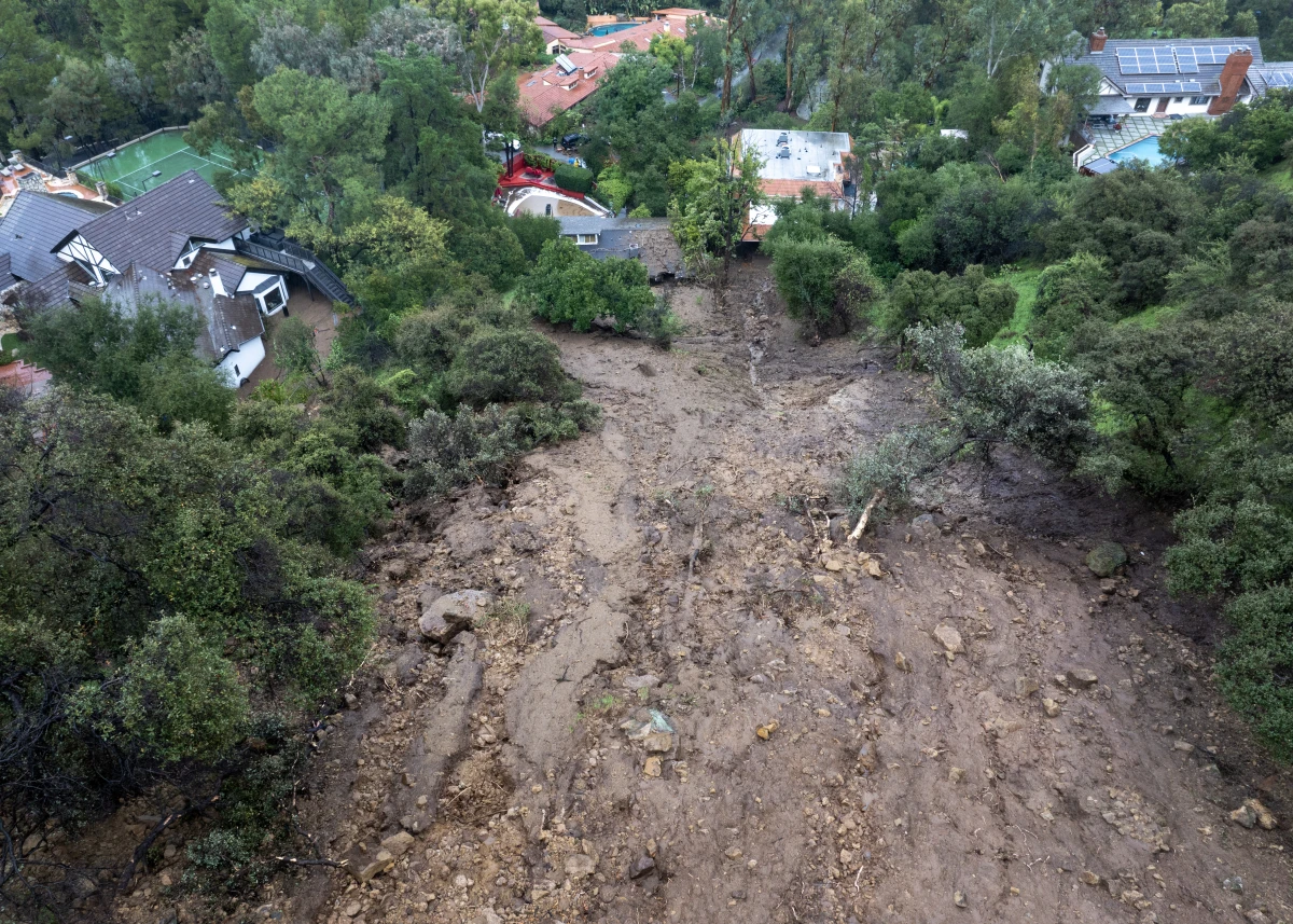
A rain-filled storm called an atmospheric river is sweeping into California this week. The weather phenomenon could bring heavy rain to many parts of the state—including the areas around Los Angeles that recently burned. Experts are warning that intense rains could create risks of debris flows and landslides in and around the burned areas.
What are atmospheric rivers?
Atmospheric rivers (ARs) are a normal part of winter weather along the West Coast. They are narrow bands of water vapor that wind sinuously through the atmosphere, like a river; they can transport vast quantities of water across the ocean, generally from the warm tropics toward the cooler mid-latitudes, like California.
One common flavor of AR, explains Christine Shields, an atmospheric scientist at the National Center for Atmospheric Research, is the colloquially termed “Pineapple Express.” Those ARs originate in the tropics near Hawaii and “essentially just move water from lower latitude to a higher latitude, like a river on earth,” she says.
When the ARs collide with the topography along the coast, they are forced upward higher in the atmosphere. That upward motion causes the water vapor they carry to turn to liquid; it falls out as rain or snow. Sometimes, the atmospheric river can also run up against other storms, adding to the atmospheric churn and often intensifying the precipitation. That may happen during this particular AR, says UCLA climate scientist Daniel Swain.
Several ARs usually arrive in California every winter, delivering as much as half the total annual precipitation to some parts of the state. This storm, forecasts project, could add 4 feet of snow to the Sierra Nevada snowpack. That snow can stay frozen until late in the summer, melting slowly and providing water downstream well into the second half of the year.
“You often hear about them when they are more extreme, and so people assume that they are hazardous,” says Julie Kalansky, director of the Center for Western Weather and Water Extremes, a group at Scripps Institution of Oceanography that studies atmospheric rivers. “But a lot of atmospheric rivers can be extremely beneficial because they bring much needed rain to our region,” she says.
Scientists at the Scripps Institution of Oceanography created a scale for ranking atmospheric rivers. It takes the duration of the potential precipitation, as well as the intensity, into account. ARs ranked 1 or 2 are “generally more beneficial,” says Kalansky. Those ranked 4 or 5 have the potential to be more dangerous, she says.
What are the concerns and risks from this atmospheric river?
This AR is currently forecast as a 1 or 2 in Southern California.
But the forecasts indicate that there could be short bursts of extra-intense rainfall, Kalansky says— similar to intense rainfall that caused flooding in San Diego in 2024.
Researchers and emergency managers are also particularly worried about severe rain falling on areas that recently burned, like in parts of Los Angeles. High-intensity fire can make soils less able to absorb water, and many of the places that burned in Southern California’s January fires have been denuded of vegetation and structures that help hold steep hills in place. A serious blast of rain, says Swain, could destabilize slopes—and potentially trigger debris flows or mudslides.
After the 2017-2018 Thomas Fire near Santa Barbara, an atmospheric river hit newly burned slopes. The total amount of rain was large, but not unprecedented—but some short bursts of rain dropped more than 3/4 inches in just 15 minutes. The intense rain triggered massive debris flows that killed more than 20 people.
Emergency managers and the National Weather Service are warning of the risks of debris flows during this atmospheric river. They are asking people to pay close attention to emergency alerts and evacuations.
Is there a climate connection?
California’s climate can shift dramatically from year to year. The big swings make seeing the fingerprint of human-caused climate change on weather events like atmospheric rivers challenging, Shields says. So far, a clear link hasn’t emerged, statistically.
But climate scientists expect that to change as the planet warms further.
“There’s very strong evidence that climate change will increase the intensity of atmospheric rivers and the rain and therefore flood risk that they produce,” says Swain.
The reason is based on well-established thermodynamics, he explains.
Human-driven climate change has primed the atmosphere to hold more of that water. Atmospheric temperatures have risen about 2 degrees Fahrenheit (just over 1 degree Celsius) since the late 1800s, when people started burning massive volumes of fossil fuels. The atmosphere can hold about 4% more water for every degree Fahrenheit warmer it gets. When that moist air hits mountains on the California coast and gets pushed upwards — or if it encounters another storm that churns the air upward into colder parts of the atmosphere — the air cools and its water gets squeezed out, like from a sponge.
It’s less clear whether, or how, climate change could influence the overall number of atmospheric rivers or the tracks they take, says Kalansky.
Swain points out that though statistical analyses don’t yet show a climate influence, some of the heaviest and most intense rainfall ever recorded at many different sites across the state have occurred in just the past few years. He calls that “anec-data—” not yet enough to provide statistical evidence, but enough to provide common-sense signals.
“That, I think, is telling us something important. Even though the long-term trend is not necessarily statistically significant, the anec-data is in alignment with what the science says should be happening.”
Transcript:
AILSA CHANG, HOST:
A powerful winter storm known as an atmospheric river is sweeping into California this week. Heavy rainfall is expected tomorrow into Friday and also risks of mudslides and floods. Alejandra Borunda from NPR’s climate desk is here to tell us more about all of this. Hi, Alejandra.
ALEJANDRA BORUNDA, BYLINE: Hi, Ailsa.
CHANG: OK. So just remind everyone, what exactly is an atmospheric river? – which is a really cool name.
BORUNDA: Right? That’s what I think, too. I’ll let atmospheric scientist Christine Shields, from the National Center for Atmospheric Research, describe them.
CHRISTINE SHIELDS: If you look at them from a satellite, they actually look a little bit like a river, where they’re sort of long and narrow and they meander.
BORUNDA: Yeah, so they’re these rivers in the sky, and they can bring a ton of water from the hot, humid tropics up towards the midlatitudes, like California. And the – I think the thing to remember is that they’re pretty common. We usually get a few every winter, except for during really intense drought years. And they deliver a really high percentage of the precipitation for the entire year for the state sometimes. So they’re really important for those states’ water resources.
CHANG: OK, so they’re really important. They’re really common. So why are people really worried about this week’s storm?
BORUNDA: Great question. So usually the concern with atmospheric rivers is flooding because the rain can come down so fast and hard, the ground just can’t absorb it or infrastructure gets overwhelmed. But right now, what most people are worried about is potential debris flows or mudslides in the burned areas around Los Angeles.
CHANG: Right.
BORUNDA: The – right. That’s because fire can make these soils actually extra bad at absorbing water. And after the burns, there’s not many trees or shrubs or whatever holding the ground in place. So these big intense bursts of rain – they can trigger slides. And people are really worried because they’ve actually seen this happen. More than 20 people died in debris flows after the Thomas fire a few years ago. It was a real wake-up call.
CHANG: Absolutely. OK, well, since you are on the climate desk, I have to ask the ever-present question, and that is, how much is climate change affecting atmospheric rivers like this one?
BORUNDA: Yeah, it’s a good question. And the short answer is that statistically, scientists don’t yet see a signal. But climate scientists like Daniel Swain from UCLA are very confident that that will change soon.
DANIEL SWAIN: There’s very strong evidence that climate change will increase the intensity of atmospheric rivers and the rain and, therefore, flood risks that they produce.
BORUNDA: So Swain says scientists don’t yet know if climate change will affect the number of atmospheric rivers or where they go. But it’s pretty simple to figure out that they will probably be more intense.
CHANG: Pretty simple maybe for an atmospheric scientist, but how would that work?
BORUNDA: I think we can understand it. The logic is tied to very well understood thermodynamics, and it’s basically this. Warm air holds more moisture. So a hotter atmosphere can soak up more water like a sponge. That extra water can then get squeezed out when the atmospheric river hits land, and that means more water comes out of the sky. And Swain points out that there’s, what he calls, anecdata (ph) that some of the state’s heaviest rain ever was in just the past few years.
SWAIN: That, I think, is telling us something important, even though the long-term trend is not necessarily statistically significant. The anecdata is in alignment with what the science says should be happening.
BORUNDA: So we know that there’s going to be some of this super intense rain in this atmospheric river. So Swain says be really careful and listen to those emergency alerts in the coming days.
CHANG: That is NPR’s Alejandra Borunda. Thank you, Alejandra.
BORUNDA: Yeah, thanks so much.